UPDATE: Tuesday, August 12th, 2014
We do our best to monitor OSS to make sure it is functioning correctly, particularly during events that impact the traveling public. You might think such events only occur during the bad weather season, but summer brings plenty of challenges including fire. For the Western States region, this is certainly turning out to be a bad fire year, particularly when coupled with the drought in California.
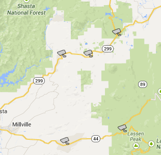
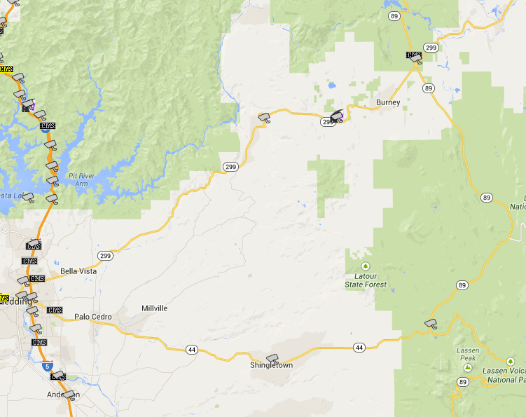
Yesterday, when checking the CCTV display in OSS in conjunction with fires in Caltrans District 2, we found something very interesting: California State Route 89 south of its intersection with SR 299 has vanished from the Google Maps!
OSS CCTV Display from 8/11/2014 with SR 89 missing south of SR 299:
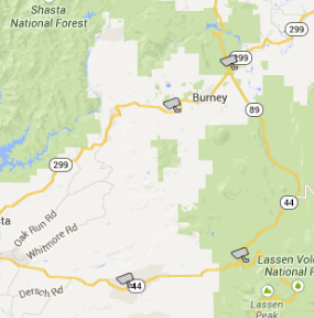
Following is a screenshot taken from OSS taken on 3/31/2014. It shows the currently missing segment of SR 89.
OSS CCTV Display from 3/31/2014 with SR-89 shown south of SR 299:
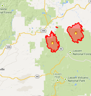
Caltrans’ QuickMap (http://quickmap.dot.ca.gov/) also uses Google Maps as a base layer, so this segment of SR 89 is absent in the QuickMap display. QuickMap does display fire information, which puts this situation into perspective. There are two large fires that have been burning in proximity to SR 89.
QuickMap Display of Fire in Proximity to SR 89:
Realizing that there are two recent, large fires in proximity to this segment of SR 89, we checked with Ian Turnbull at District 2 to find out if SR 89 was still closed. It was not. The Caltrans District 2 Twitter feed confirmed this, showing that SR 89 had reopened on August 6th.
Caltrans District 2 Twitter Feed Showing Information about the SR 89 Closure:
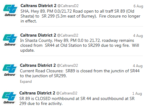
Information from Inciweb about the Eiler Fire (http://inciweb.nwcg.gov/incident/4037) and the Bald Fire (http://inciweb.nwcg.gov/incident/4022/) are consistent with the information from Caltrans:
Inciweb Statement Regarding SR 89:

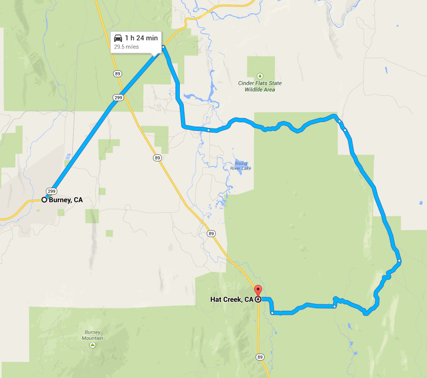
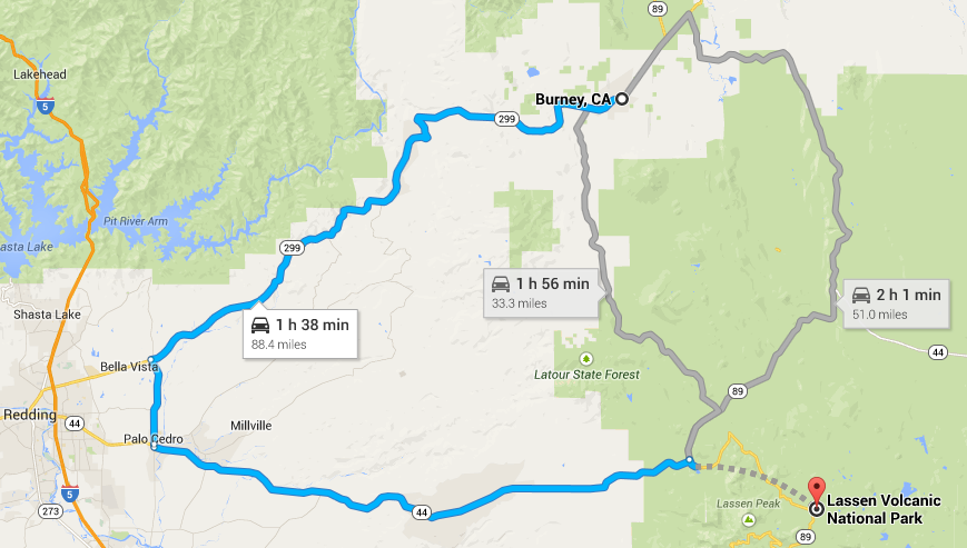
The absence of this segment of SR 89 isn’t just relevant to display – it’s also apparent in routing. While this segment of SR 89 is missing from the Google Maps display, Google currently appears to only provide directions that exclude this segment. Routes from Burney to Lassen Park are shown below. Note that the preferred route nearly goes to Redding, principally following SR 299 and SR 44 for almost 90 miles. The two alternate routes shown are shorter, but are estimated to take longer because they follow Forest Service roads. Even under ideal circumstances, it would not be advisable to travelers unfamiliar with the area to take these routes. In the presence of active fires, travelers may want to avoid these routes altogether.
Routes from Burney, CA to Lassen Park Shown by Google Maps on 8/11/2014:
So, what explains the disappearance of SR 89 and is it related to the fires? In short, we suspect it is related to the fires, but we can’t confirm this. We can, however, look for further clues via Google:
Google uses crowdsourcing to enhance their map content. See:
https://sites.google.com/site/mapmakerpedia/
maps-101/collaborative-mapping-crowdsourcing. Google even allows users to “edit” Google Maps
using Google Map Maker (http://www.google.com/mapmaker). While this functionality
certainly doesn’t and shouldn’t allow individual users to make changes such as the removal of a large segment of a state highway, it does allow
them to submit changes which we suspect go through some sort of internal confirmation process before being presented to the public. Changes
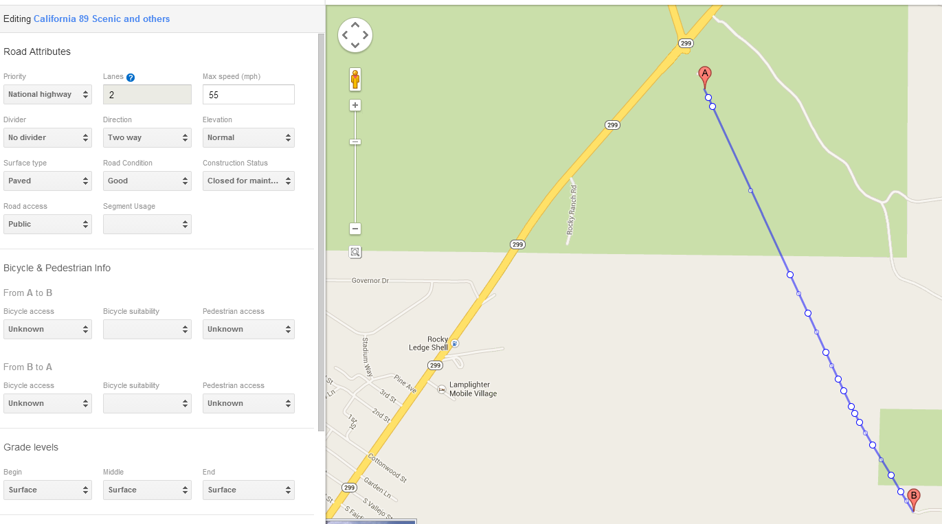
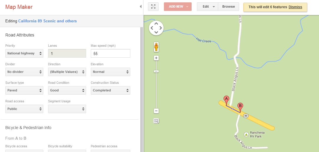
users can suggest include an attribute called “Construction Status”, and, as shown below, the Construction Status for a portion of the missing
segment from SR 89 shows a status of “Closed for maintenance”. We suspect this is the reason that SR 89 is missing from the map. We haven’t been
able to determine, however, when and why this change was made. Perhaps it was done in conjunction with last week’s closure. If that was the case,
then the status should have been changed back when the road re-opened. Obviously it has not been changed back.
Google Map Maker Showing Attributes for a Segment of SR 89 south of SR 299:
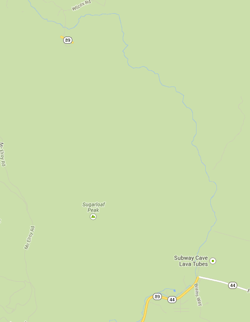
We’ve noticed something else odd in regard to Google Maps and SR 89. There’s a tiny little section of SR 89 that does appear on the map, disconnected from all other roads. Sure enough, the Construction Status for this segment is “Completed”.
Isolated Segment of SR 89 Shown in Google Maps:
Google Map Maker Attributes for Isolated Segment of SR 89:
We cannot say with certainty what caused this problem but we suspect that either directly or following public input through a mechanism such as Google Map Maker, Google Maps changed the Construction Status of SR 89 to “Closed for Maintenance” to preclude routing while this segment was closed due to the fire. Regardless of how this happened, the status should be changed back to “Complete” to show SR 89 on the map again since it is currently open.
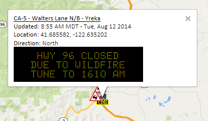
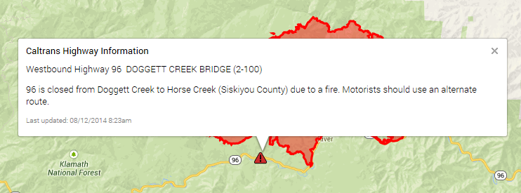
Even if our hunch is correct, we find the situation to be odd. Should a road be removed entirely from display if it is closed, or should an alternate mechanism be used to indicate the closer? If the SR 89 segment was hidden from view because of the prior closure, then we would expect to see similar handling for other closures. But that isn’t the case. There is currently a closure on California SR 96 due to fire, yet SR 96 still appears on the map.
Highway 96 Closure Indicated on CMS in OSS:
Highway 96 Closure Indicated in QuickMap along with Fire Perimeter:
As mentioned at the beginning of this message, we try to ensure that OSS is functioning correctly and that it is displaying accurate information. The SR 89 example shows that some things are out of our control. We could attempt to change the status of this segment via Google Map Maker, but we’re not really comfortable in doing so. There is an alternative:
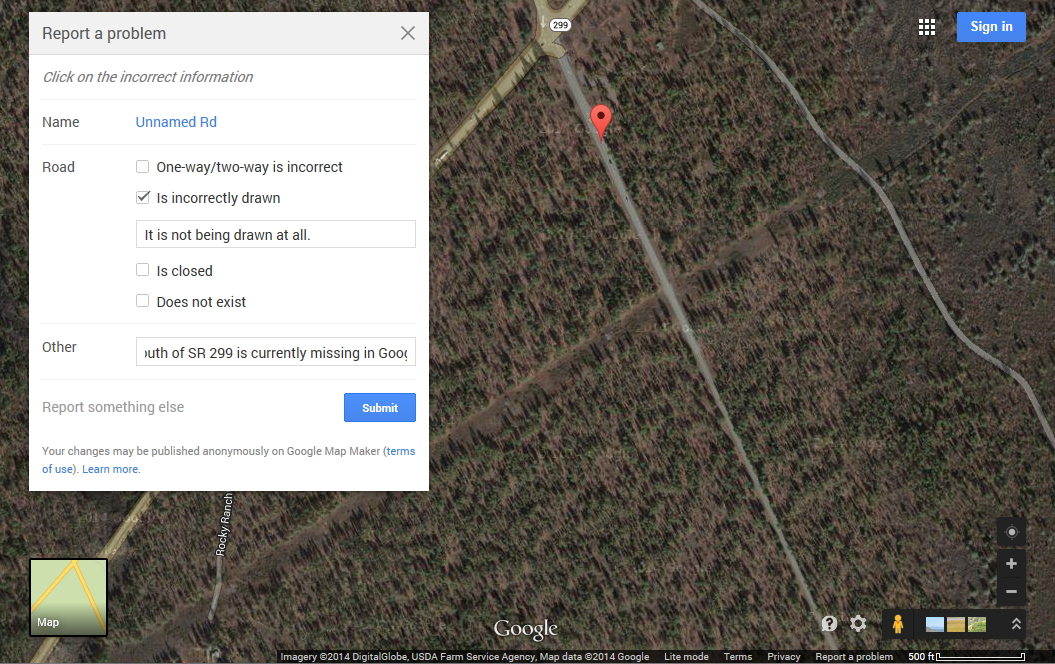
Google provides a “Report an Error” link in Google Maps, which we can use to inform Google of the problem. But there may be a problem with this approach – we need to identify the problematic feature on the map, and the problem is that the feature isn’t displayed. So … we switch to satellite view and click on the image of the roadway. Our selection is identified as “Unnamed Rd”. We tried multiple times at different spots along SR 89, but didn’t get a result indicating “SR 89” so we used “Unnamed Rd”. Next, the list of problems Google provides us is problematic too because none fit the situation very well. “Is incorrectly drawn” is probably the closest choice, so we use that and add several notes indicating the SR 89 isn’t being drawn at all. At this point, there is no further information we can add, so we submit the error report as shown below:
Reporting the Error in Google Maps:
Hopefully this provides Google with enough information to recognize and address the problem. We’ll monitor the situation see how long it takes for this to get fixed.
Separate from our curiosity about this situation, there is an important message here for users of OSS and travelers in general: When traveling in the presence of adverse conditions, use all sources of information available to you, and be careful in making what could be a life and death decision based on the guidance of technology alone. Just because your GPS or your smartphone recommends a route for you to follow, you shouldn’t follow it blindly.
Addendum (August 13, 2014):
SR 89 is back! Almost ... As of this morning, we see that SR 89 is displayed again in Google Maps via OSS and elsewhere.
SR 89 Displayed Again in OSS:
Unfortunately, Google Maps appears to still avoid this segment of SR-89 when providing directions. At least the road is back on the map!
Google Directions from Burney to Hat Creek, still avoiding SR 89:
